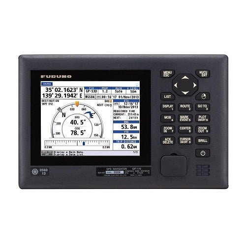
The Furuno GP170 is an IMO-approved, 5.7-inch color GPS display designed for ocean-going ships, ferries, large yachts, and commercial vessels. It delivers precise positioning with SBAS augmentation and integrates easily with radar, AIS, ECDIS, Autopilot, and other navigation systems.
-
Display: 5.7 in color LCD, 640 x 480 resolution, brightness 700 sc/m2
-
Positioning & Accuracy: 12 GPS channels, SBAS 2 channels; GPS ≤ 10 m, WAAS ≤ 3 m, MSAS ≤ 7 m
-
Position update rate: Standard 1 second, maximum 0.1 second
-
Antenna performance: Enhanced stability and precision with noise rejection and anti-jamming; improved multi-path tolerance when GPA020S or GPA021S antenna units are used
-
Display modes: Plotter, Highway, Course, Data, Integrity (Integrity mode shows satellite status, GNSS/SBAS reception strength, SNR, and beacon information)
-
Memory & Routes: 1,000 ship's track points with 20-character comments; 2,000 waypoints; 100 routes up to 1,000 waypoints each
-
Alerts & Integrity: Alerts for differential positioning interruption, HDOP overshoot, own ship positioning fail/lost, BEACON signal issues, and antenna short-circuit
-
Interfaces: USB front panel for data export/import; Ethernet port (IEC 61162-450); Serial ports: 2 In/Out and 1 Out (IEC 61162-1, IEC 61162-2)
-
Bridge integration: BAM (Bridge Alert Management) ready for coordinated bridge operations
-
Power & Dimensions: 12–24 V DC; 9.84 in W x 6.29 in H x 3.5 in D
-
What’s in the box: GP170 Display, GPA017S Antenna, 15 m Antenna Cable, Power Cord, Operators Manual, Installation Manual, Operators Guide, Fuse 3A, Cable Tie, Self-tapping Screws x4, LCD Cleaning Cloth
-
Antenna options: GPA020S or GPA021S antenna units enhance multipath tolerance
-
Compliance: Full IMO MSC.114(73) and IEC 61108-4 compliance
Experience reliable, shipboard navigation with precise, SBAS-augmented positioning and fast updates that support accurate own-ship tracking even in challenging seas. The GP170’s multiple display modes and rich memory enable tailored route planning, quick data export/import, and smooth integration with bridge systems, radar, AIS, ECDIS, and autopilot. Its anti-jamming and multipath-tolerant design—especially when paired with GPA020S or GPA021S antennas—reduces position uncertainty and enhances safety during critical operations. Designed for ocean-going vessels and large fleets, it delivers a stable, user-friendly navigation sensor that improves situational awareness and operation efficiency.
Number of ChannellsGPS:12Ch
SBAS 2 Ch |
| Accuracy |
GPS - Not exceeding 10m (2 drms, HDOP <4)
WAAS - Not exceeding 3m (2 drms, HDOP <4)
MSAS - Not exceeding 7m (2 drms, HDOP <4) |
| Trackign velocity |
1,000 kn |
| Position fixing time |
90 seconds when cold start |
| Position update rate |
1 second standard, 0.1 sec max |
| Display unit |
| Screen size |
5.7 in color LCD |
| reslution |
640 x 480 |
| Brightness |
700 sc/m2 |
| Display modes |
Plotter, highway, course, data, integrity |
| Memory |
1,000 points for ship's track with comments up to 20 characters; 2,000 points for waypoints; 100 routes 9 containing upt o 1,000 waypoints per route) |
| Alert |
Differential positioning interruption, HDOP overshoot, own ship positioning fail, own ship position lost, BEACON signal lost, Beacon malfunction, antenna short-circuit |
| Notice |
Arrival and anchor watch, XTE, Speed, Trip |
| Integrity indication |
Safe, Unsafe, Caition |
| Ports |
Serial ports: 2 ports (In/Out), 1 port (Out) IEC 61162-1, 1 port (in/Out) IEC 61162-2; Ethernet: 1 port IEC 61162-450; USB 1 port ( front panel) |
| Envirioment |
| Input Voltage |
12-24vDC |
| Dimensions |
9.84 in w x 6.29 in H x 3.5 in D |