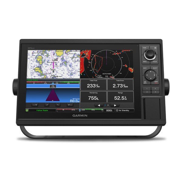
Meet the Garmin GPSMAP 1222 12-inch Plotter Worldwide Basemap—a premier navigation hub built for cruisers, sailors, and racing crews who demand precise charts, fast updates, and robust connectivity at sea.
-
12-inch WXGA display with tactile controls: Large, bright color screen paired with a tactile keypad and a multifunction control knob for quick, intuitive operation in challenging conditions.
-
10 Hz GPS/GLONASS receiver: High-sensitivity position and heading updates at 10 Hz for smoother on-screen movement and reliable guidance.
-
Worldwide Basemap with BlueChart g2 Vision HD option: Global chart coverage with an optional premium BlueChart g2 Vision HD for Auto Guidance and advanced navigation features.
-
Two SD card slots for expandable maps: Add LakeVü HD, LakeVü HD Ultra, BlueChart g2 HD, or BlueChart g2 Vision HD maps to tailor charting to your voyage.
-
Auto Guidance and advanced charting tools: Smart routing and enhanced charting to help you plan safer passages with confidence.
-
Rugged, network-ready performance: Fully network capable with Garmin Marine Network, NMEA 2000, and NMEA 0183 support for autopilots, weather, VHF, AIS, FUSION-Link, and more.
-
Data sharing across your boat: Share sonar, maps, user data, radar, IP cameras, and Panoptix sonar among multiple Garmin units for cohesive navigation.
-
Built-in Wi‑Fi for mobile planning: Plan routes and monitor your chartplotter from a smartphone or tablet with BlueChart Mobile 2.0 and Garmin Helm support.
-
ANT wireless connectivity: Integrates with quatix marine watches, Garmin Nautix in-view displays, gWind Wireless 2 transducers, GNX Wind instruments, and wireless remotes for integrated control.
-
Smart sailing features: Pre-race guidance page with virtual starting line, laylines, time to burn, and a synchronized race timer across Garmin devices; enhanced wind rose and true vs. apparent wind data for strategic decisions.
-
GPX data transfer: Import and reuse waypoints, tracks, or routes from other devices via GPX formatting for seamless data transfer.
-
Expandable for long voyages: Memory supports up to 5,000 waypoints, 100 routes, and 50,000 track points; multiple network options and map purchases to grow with your voyages.
-
Reliability for demanding conditions: Designed to meet the needs of cruising, sailing, and racing in varied marine environments.
-
SiriusXM Weather & Radio compatible: Access weather and radio data where SiriusXM services are available.
-
Physical & compatibility details: 14.1" x 8.9" x 2.7" chassis; display 10.3" x 6.4" with 1280 x 800 resolution; weight 5.2 lbs; IPX7 water rating; NMEA 2000 and NMEA 0183 compatible; supports internal or external antennas.
The GPSMAP 1222 consolidates navigation, planning, and data sharing into a single, capable plotter. It speeds route planning with fast position updates, elevates situational awareness through cross‑device data sharing, and supports long voyages with expandable maps and memory. For racing or cruising alike, it blends smart sailing features with dependable connectivity to keep your crew informed and aligned—from autopilots to radar—on every voyage or race day.
| Performance and Physical |
| Dimensions |
14.1" x 8.9" x 2.7" (35.8 x 22.6 x 6.9 cm) |
| Display size |
10.3" x 6.4" (26.2 x 16.3 cm) |
| Display resolution |
1280 x 800 |
| Display type |
WXGA display |
| Weight |
5.2 lbs |
| Water rating |
IPX7 |
| Antenna |
Internal or external over NMEA 2000 |
| NMEA 2000® compatible |
Yes |
| NMEA 0183 compatible |
Yes |
| SiriusXM™ Weather & Radio compatible |
Yes |
| Power consumption |
Max power usage at 10 Vdc: 34.8 W
Typical current draw at 12 Vdc: 2.2 A
Max current draw at 12 Vdc: 2.9 A |
| Mounting options |
Bail or flush |
| Maps and Memory |
| Preloaded maps |
None |
| Accepts data card |
2 SD™ cards |
| Waypoints |
5,000 |
| Routes |
100 |
| Track log |
50,000 points; 50 saved tracks |
| Outdoor Recreation Features |
| Tide tables |
Yes |
| Chartplotter Features |
| Garmin Radar compatible |
Yes |
| Garmin Sonar compatible |
Yes (with external black box, sold separately) |
| Garmin SmartMode compatible (customizable monitor presets) |
Yes |
| Supports AIS (tracks target ships position) |
Yes |
| Supports DSC (displays position data from DSC-capable VHF radio) |
Yes |
| Garmin Meteor™ Audio System compatible |
Yes |
| Supports FUSION-Link™ compatible radios |
Yes |
| GSD™ Black Box sonar support |
Yes |
| GCV™ Black Box sonar support |
Yes |
| ActiveCaptain compatible |
Yes |
| Garmin Helm compatible |
Yes |
| GRID™ (Garmin Remote Input Device) compatible |
Yes |
| Wireless remote compatible |
Yes |
| Sonar Features & Specifications |
| CHIRP sonar technology |
Yes (with external black box, sold separately) |
| ClearVü |
Yes (with external black box, sold separately) |
| SideVü |
Yes (with external black box, sold separately) |
| Connections |
| NMEA 2000® compatible |
Yes |
| NMEA 0183 input ports |
1 |
| NMEA 0183 output ports |
1 |
| Video input ports |
1 BNC |
| Video output ports |
None |
| Wireless connectivity |
Yes |