Garmin GPSMAP 79s Marine Handheld GPS combines rugged, floating reliability with advanced navigation technology for any waterborne adventure. With a bright high‑resolution color display, scratch‑resistant, fogproof glass, and multi‑constellation satellite support, this handheld navigator keeps you on course when the conditions get rough.
Key Features
-
Rugged, floating design built to endure marine environments and stay afloat if dropped overboard.
-
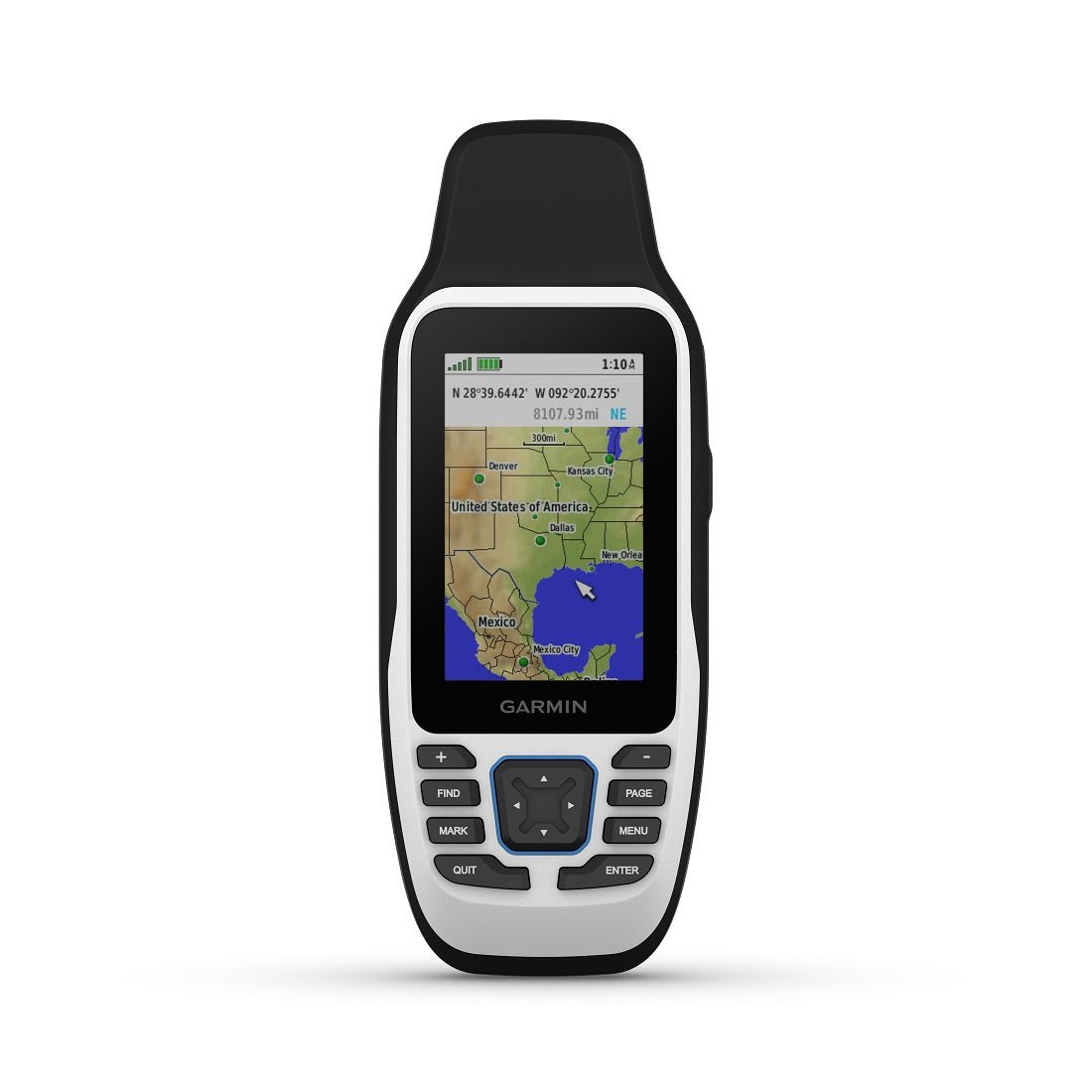
High‑contrast display sunlight‑readable 3" color screen with scratch‑resistant, fogproof glass for easy reading in bright sunlight or spray.
-
Multiconstellation satellite support for reliable tracking worldwide: GPS, GLONASS, Beidou, Galileo, QZSS and SBAS.
-
Worldwide basemap included with the ability to add detailed offshore or onshore maps as needed.
-
Extensive memory save and track up to 10,000 waypoints, 250 routes, and 300 fitness activity files.
-
Advanced navigation sensors built‑in 3‑axis tilt‑compensated electronic compass (shows heading even while stationary) and a barometric altimeter to track pressure changes and elevation.
-
Hydrographic detail includes coastlines, lakes, river shorelines, wetlands and perennial/seasonal streams (downloadable maps via Garmin Express).
-
Road and outdoor routing turn‑by‑turn navigation for outdoor activities (requires optional detailed road maps).
-
POIs and search easily locate parks, campgrounds, scenic lookouts, picnic sites and more.
-
Connectivity and compatibility high‑speed microUSB interface and NMEA 0183 compatibility for external devices and data sharing.
-
Battery life user‑replaceable AA batteries provide up to 19 hours of GPS tracking.
-
Dimensions and build compact handheld (2.67" x 6.85" x 1.67"), 9.95 oz with batteries, designed for tough marine use.
Performance and Durability
Designed for life on the water, the GPSMAP 79s delivers a reliable fix with robust, IP‑level water resistance and floating capability. Its transflective display is optimized for sunlit conditions, ensuring you can navigate confidently even when glare is an issue. The 3‑axis tilt‑compensated compass keeps your heading accurate whether you’re paddling, docking, or charting a course at rest, while the barometric altimeter helps you monitor weather changes and altitude precisely.
Maps, Memory and Navigation
With a generous 8 GB of internal memory and support for additional maps, you can store thousands of waypoints and routes to plan complex expeditions. The GPSMAP 79s includes a worldwide basemap and supports optional detailed mapping for even more precise road navigation when needed. It also provides automatic routing on roads for outdoor activities, making it a versatile tool for boating, hiking, or exploring remote coastlines.
Why This Garmin GPSMAP 79s?
Whether you’re navigating offshore, charting inland waterways, or planning multi‑day trips, the GPSMAP 79s combines rugged durability with advanced sensors and expansive memory to keep you oriented and on track. Its long battery life, multi‑satellite capability, and comprehensive hydrographic data make it a dependable companion for serious mariners and outdoor enthusiasts alike.
| General |
| PHYSICAL DIMENSIONS |
2.67'' x 6.85'' x 1.67'' (6.77 x 17.40 x 4.23 cm) |
| DISPLAY SIZE |
1.5"W x 2.5"H (3.8 x 6.3 cm); 3" diag (7.6 cm) |
| DISPLAY RESOLUTION |
240 x 400 pixels |
| DISPLAY TYPE |
transflective, 65K color TFT |
| WEIGHT |
9.95 oz (282g) with batteries |
| BATTERY TYPE |
2 AA batteries (not included); NiMH or Lithium recommended |
| BATTERY LIFE |
up to 19 hours |
| WATER RATING |
IPX7 |
| MIL-STD-810 |
yes (thermal, shock, water); bare unit only |
| HIGH-SENSITIVITY RECEIVER |
Yes |
| INTERFACE |
high speed microUSB and NMEA 0183 compatible |
| MEMORY/HISTORY |
8 GB (user space varies based on included mapping on sc version) |
| Maps & Memory |
| PRELOADED MAPS |
No |
| ABILITY TO ADD MAPS |
Yes |
| basemap |
Yes |
| AUTOMATIC ROUTING (TURN BY TURN ROUTING ON ROADS) FOR OUTDOOR ACTIVITIES |
Yes (with optional mapping for detailed roads) |
| MAP SEGMENTS |
15000 |
| INCLUDES DETAILED HYDROGRAPHIC FEATURES (COASTLINES, LAKE/RIVER SHORELINES, WETLANDS AND PERENNIAL AND SEASONAL STREAMS) |
Yes (downloadable from Garmin Express™) |
| INCLUDES SEARCHABLE POINTS OF INTERESTS (PARKS, CAMPGROUNDS, SCENIC LOOKOUTS AND PICNIC SITES) |
Yes (downloadable from Garmin Express™) |
| DISPLAYS NATIONAL, STATE AND LOCAL PARKS, FORESTS, AND WILDERNESS AREAS |
Yes (downloadable from Garmin Express™) |
| EXTERNAL MEMORY STORAGE |
yes (32 GB max microSD™ card, not included) |
| WAYPOINTS/FAVORITES/LOCATIONS |
10000 |
| TRACKS |
250 |
| TRACK LOG |
20,000 points, 250 saved gpx tracks, 300 saved fit activities |
| 20,000 points, 250 saved gpx tracks, 300 saved fit activities |
250, 250 points per route; 50 points auto routing |
| RINEX LOGGING |
Yes |
| Sensors |
| GPS |
Yes |
| GLONASS |
Yess |
| Galileo |
Yes |
| QZSS |
Yes |
| Compass |
Yes (tilt-compensated 3-axis) |
| GPS COMPASS (WHILE MOVING) |
Yes |
| Outdoor Recreation |
| POINT-TO-POINT NAVIGATION |
Yes |
| AREA CALCULATION |
Yes |
| HUNT/FISH CALENDAR |
Yes |
| GEOCACHING-FRIENDLY |
Yes (Paperless) |
| CUSTOM MAPS COMPATIBLE |
Yes |
| PICTURE VIEWER |
Yes |