Couldn't load pickup availability
About the Product
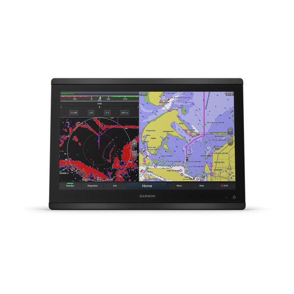
Meet the Garmin GPSMAP8416 16" Plotter Worldwide Basemap — a premium chartplotter designed for cruising, racing and demanding marine environments. The 16" full HD IPS touchscreen delivers crisp, distraction-free viewing with wide angles and sun readability, even when wearing polarized sunglasses. This compact, easy-to-install system packs MFD-level performance into a sleek, glass-helm-ready package.
Key features
- 16" full HD IPS touchscreen provides large, glare-free charts with excellent contrast and readability from any angle.
- Edge-to-edge displays can be mounted flat or flush for a modern glass helm look.
- NMEA 2000 and Garmin Marine Network enable easy integration with radar, autopilots, cameras, forward-looking sonar and more, shared across multiple screens.
- Bluetooth, ANT and Wi‑Fi keep you connected to the ActiveCaptain app, Garmin Cloud and wireless peripherals.
- SailAssist with prerace data and race-ready guidance for racers and serious sailors.
- SmartMode station controls provide quick, one-touch access to critical information for docking and navigation.
- OneHelm compatibility coordinates third-party onboard systems for centralized control from your chartplotter.
- USB touch output lets the device double as a touchscreen monitor for Windows and Mac.
- Expandable memory for BlueChart g3 and BlueChart g3 Vision (Navionics data) and Auto Guidance that suggests routes based on your vessel’s specs.
- ActiveCaptain integration, OneChart access, smart notifications and Quickdraw community data through built-in Wi‑Fi.
- Video and camera support for GC™ 100 wireless cameras and VIRB® action cameras; ANT connectivity with quatix watches and wind transducers.
- Optional GRID 20 remote input with 360-degree joystick for intuitive deck control and menu navigation.
Performance and versatility
The GPSMAP 8416 is powered by a premium-performance processor for fast map drawing, robust networking and smooth video distribution. It enables OneChart and ActiveCaptain collaboration, sharing data across displays and devices for a cohesive marine network. The integrated Auto Guidance technology shows suggested routes tailored to your vessel, while the Navionics and BlueChart datasets provide the most detailed charts worldwide.
Designed for a modern helm
With its sleek, glass-helm-ready form factor, the GPSMAP 8416 supports multiple configurations — edge-to-edge displays, flush mounting, or combined installations — to achieve a clean, professional look. The easy-to-use interface, USB touchscreen capability, and SmartMode controls empower you to manage complex systems with confidence, even in high-stress docking situations.
Optimized navigation for speed and safety
Whether you’re cruising the coast or racing offshore, the GPSMAP 8416 delivers fast map drawing, networked sonar, radar, cameras, media and digital switching—seamlessly integrated and accessible from your chartplotter screen or across your Garmin marine network.
| General | |
| Physical dimensions | 15.1" x 10.3" x 3" (38.5 cm x 26.3 cm x 7.6 cm) |
| Weight | 9.6 lbs (4.4 kg) |
| Water rating | IPX6 and IPX7 |
| Display type | touchscreen IPS display (anti-glare finish) |
| Display size | 13.6" x 7.7" (34.5 cm x 19.5 cm) |
| Display resolution | FHD; 1920 x 1080 pixels |
| Power consumption | 3.5 A |
| Antenna | Internal or external over NMEA 2000 |
| Mounting options | Flat and flush, bail with optional accessory (Garmin does not offer any hardware or accessories for a flat-mount installation. Professional tools and knowledge is required.) |
| Receiver | 10 Hz GPS/GLONASS/Galileo |
| Garmin Marine Network™ ports | 2 |
| Maps & Memory | |
| Accepts data cards | 2 microSD cards (on back) |
| Waypoints | 5,000 |
| Routes | 100 (250 waypoints each) |
| Track log | 50,000 points; 50 saved tracks |
| pre-loaded maps | Worldwide Basemap |
| Outdoor Recreation Features | |
| Tide tables | Yes |
| Chartplotter Features | |
| Garmin Radar compatible | Yes |
| Garmin Sonar compatible | Yes |
| Garmin SmartMode compatible (customizable monitor presets) | Yes |
| Supports AIS (tracks target ships position) | Yes |
| Supports DSC (displays position data from DSC-capable VHF radio) | Yes |
| Supports FUSION-Link™ compatible radios | Yes |
| GSD™ Black Box sonar support | Yes |
| GCV™ Black Box sonar support | Yes |
| ActiveCaptain compatible | Yes |
| Garmin Helm compatible | Yes |
| GRID™ (Garmin Remote Input Device) compatible | Yes |
| Wireless remote compatible | Yes |
| Sonar Features & Specifications | |
| Dual-frequency (50/200 kHz) sonar capable | Yes (with external black box, sold separately) |
| Dual-beam (77/200 kHz) sonar capable | Yes (with external black box, sold separately) |
| Frequencies supported | NA |
| Transmit power | NA |
| CHIRP sonar technology | Yes_(when_connected_to_another_compatible_sonar_device) |
| ClearVü | yes (with GCV™ black box, sold separately) |
| SideVü | yes (with GCV™ black box, sold separately) |
| Maximum depth | NA |
| Connections | |
| NMEA 2000® compatible | Yes |
| Transducer pin numbers | NA |
| NMEA 0183 input ports | 1 differential |
| NMEA 0183 output ports | 1 differential |
| Video input ports | 1 - BNC composite 1 - HDMI (HDCP compliant) |
| Video output ports | 1 HDMI |
| Wireless connectivity | Yes |
Text block