Garmin GPSMAP 8416xsv 16" Comb Worldwide Basemap is a premium chartplotter/sonar combo designed for serious sport fishermen, cruisers, and sail racers. With a 16" full HD IPS touchscreen and a worldwide basemap, this all‑in‑one marine MFD delivers unmatched clarity, speed, and networked control from the helm.
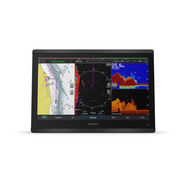
Brilliant, Sunlight-Ready Display
The 16" full HD IPS touchscreen provides wide viewing angles, superb clarity, and excellent readability in bright sun—even when you’re wearing polarized sunglasses. You can edge‑to‑edge mount multiple displays for a sleek glass-helm look or mount flush for a clean, integrated cockpit aesthetic.
Industry-Leading Sonar, Built In
Benefit from built‑in support for Garmin’s powerful sonar suite, including dual‑channel 1 kW traditional CHIRP, CHIRP ClearVü, and CHIRP SideVü scanning sonars. Also supported is Ultra HD scanning sonar with no external black box required, plus compatibility with Panoptix all‑seeing sonar (transducers sold separately). It’s the ultimate depth, structure, and fish targeting toolkit, right at your fingertips.
Connect, Control, and Share Everywhere
Designed to grow with your system, GPSMAP 8416xsv features NMEA 2000 networking and Garmin Marine Network to easily integrate radar, autopilots, cameras, instruments, and forward‑looking sonar across multiple screens. OneHelm coordination brings third‑party onboard systems under your chartplotter screen for streamlined control of digital switching, lighting, stabilization, and more.
- Built‑in Wi‑Fi for ActiveCaptain, OneChart, smart notifications, and community data
- Bluetooth, ANT, and wireless compatibility with quatix marine watch, gWind transducer, and more
- GC™ 100 wireless camera and VIRB® action camera integration for live video and playback
Smart, Quick Access at Your Fingertips
Sharp processor performance enables fast map drawing, responsive navigation, and powerful video distribution. SmartMode gives you one‑touch access to the information you need in high‑stress moments, such as docking, navigation cues, and engine or vessel status—reducing workload and increasing confidence on deck.
SailSmart Features for Competitive Edge
Our SailAssist™ suite delivers data, displays and prerace guidance to help you gain an advantage on the water. Expect laylines, enhanced wind rose, heading and course‑over‑ground lines, true wind data fields, and tide/current/time sliders to keep you on the fastest tack and the best beat.
Worldwide basemap, Flexible Mounting, and Premium Build
The GPSMAP 8416xsv includes a robust worldwide basemap and a premium‑performance processor that delivers crisp graphics, fast route calculations, and reliable operation across a wide range of marine conditions. Whether you prefer a flat, edge‑to‑edge installation or a flush mount for a seamless helm, this unit is engineered for a clean, modern cockpit look with peak performance.
Key Benefits
- All‑in‑one 16" chartplotter, sonar, and charting system with worldwide basemap
- Built‑in CHIRP, ClearVü, SideVü, and Ultra HD scanning sonar without a separate box
- Extensive connectivity: NMEA 2000, Garmin Marine Network, Wi‑Fi, Bluetooth, ANT
- OneHelm integration for centralized control of onboard systems
- ActiveCaptain with OneChart, Quickdraw community data, and smart notifications
- SailAssist features for competitive sailing and prerace guidance
- Flexible mounting options for a sleek, glass‑helm look
| General |
| Physical dimensions |
15.1" x 10.3" x 3" (38.5 cm x 26.3 cm x 7.6 cm) |
| Weight |
9.6 lbs (4.4 kg) |
| Water rating |
IPX6 and IPX7 |
| Display type |
touchscreen IPS display (anti-glare finish) |
| Display size |
13.6" x 7.7" (34.5 cm x 19.5 cm) |
| Display resolution |
FHD; 1920 x 1080 pixels |
| Power consumption |
4.2 A |
| Antenna |
Internal or external over NMEA 2000 |
| Mounting options |
Flat and flush, bail with optional accessory (Garmin does not offer any hardware or accessories for a flat-mount installation. Professional tools and knowledge is required.) |
| Receiver |
10 Hz GPS/GLONASS/Galileo |
| Garmin Marine Network™ ports |
2 |
| Maps & Memory |
| Accepts data cards |
2 microSD cards (on back) |
| Waypoints |
5,000 |
| Routes |
100 (250 waypoints each) |
| Track log |
50,000 points; 50 saved tracks |
| pre-loaded maps |
Worldwide Basemap |
| Outdoor Recreation Features |
| Tide tables |
Yes |
| Chartplotter Features |
| Garmin Radar compatible |
Yes |
| Garmin Sonar compatible |
Yes |
| Garmin SmartMode compatible (customizable monitor presets) |
Yes |
| Supports AIS (tracks target ships position) |
Yes |
| Supports DSC (displays position data from DSC-capable VHF radio) |
Yes |
| Supports FUSION-Link™ compatible radios |
Yes |
| GSD™ Black Box sonar support |
Yes |
| GCV™ Black Box sonar support |
Yes |
| ActiveCaptain compatible |
Yes |
| Garmin Helm compatible |
Yes |
| GRID™ (Garmin Remote Input Device) compatible |
Yes |
| Wireless remote compatible |
Yes |
| Sonar Features & Specifications |
| Dual-frequency (50/200 kHz) sonar capable |
Yes |
| Dual-beam (77/200 kHz) sonar capable |
Yes |
| Frequencies supported Regular |
Traditional: 50/200, 77/200, 83/200 Single Channel CHIRP: 40-250
Dual Channel CHIRP: 40-250
SideVü/ClearVü: CHIRP 260/455/800
(dependent on transducer) |
| Frequencies supported Ultra High Definition |
Ultra High-Definition ClearVü: 0.8 MHz (800 kHz), CHIRP range: 760-880 kHz
Ultra High-Definition SideVü: 1.2 MHz (1,200 kHz), CHIRP range: 1,060-1,170 kHz
(dependent on transducer) |
| Transmit power |
1 kW traditional; 1 kW CHIRP |
| CHIRP sonar technology |
Yes (Built-in) |
| ClearVü |
Yes |
| SideVü |
Yes |
| Maximum depth |
5,000 ft at 1kW (depth capacity is dependent on water bottom type and other water conditions) |
| Connections |
| NMEA 2000® compatible |
Yes |
| Transducer pin numbers |
1 — LVS sonar, 1 — 12 pin scanning sonar, 1- 8 pin sonar |
| NMEA 0183 input ports |
1 differential |
| NMEA 0183 output ports |
1 differential |
| Video input ports |
1 - BNC composite
1 - HDMI (HDCP compliant) |
| Video output ports |
1 HDMI |
| Wireless connectivity |
Yes |