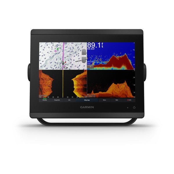
Garmin GPSMAP 8610xsv is a 10-inch chartplotter/sonar combo designed for serious offshore adventures and inshore excursions alike. It pairs a bright IPS touchscreen with an integrated high‑definition sonar suite and Navionics+ charts for the U.S. and Canada, delivering precise maps and live sonar imagery to navigate with confidence.
The GPSMAP 8610xsv delivers a cohesive navigation and sonar experience for anglers, cruisers, and competitive sailors who demand precise coastal planning, deep-water scanning, and a streamlined helm. Auto Guidance+ aids route planning, OneHelm keeps compatible devices under centralized control, and ActiveCaptain updates ensure your charts stay current. The built‑in high‑definition sonar covers bottom structure to live feed, while Navionics+ charts provide reliable mapping across the U.S. and Canada right out of the box. With durable construction, flexible mounting, and generous memory, this system is built to perform in demanding marine environments.
| General |
| Physical dimensions |
10.25" x 8.0625" x 2.95" (25.9 cm x 20.5 cm x 7.5 cm) |
| Weight |
5.2 lbs (2.4kg) |
| Water rating |
IPX6 and IPX7 |
| Display type |
touchscreen IPS display (anti-glare finish) |
| Display size |
8.6" x 5.4" (21.8 cm x 13.7 cm) |
| Display resolution |
WUXGA; 1920 x 1200 pixels |
| Power consumption |
2.7 A |
| Antenna |
Internal or external over NMEA 2000 |
| Mounting options |
Bail, flat or flush (Garmin do not offer any hardware or accessories for a flat-mount installation. Professional tools and knowledge is required.) |
| Receiver |
10 Hz GPS/GLONASS/Galileo |
| Garmin Marine Network™ ports |
2 |
| Maps & Memory |
| Accepts data cards |
2 microSD cards (on back) |
| Waypoints |
5,000 |
| Routes |
100 (250 waypoints each) |
| Track log |
50,000 points; 50 saved tracks |
| pre-loaded maps |
Garmin Navionics+ coastal and inland water charts for the U.S. and Canada |
| Outdoor Recreation Features |
| Tide tables |
Yes |
| Chartplotter Features |
| Garmin Radar compatible |
Yes |
| Garmin Sonar compatible |
Yes |
| Garmin SmartMode compatible (customizable monitor presets) |
Yes |
| Supports AIS (tracks target ships position) |
Yes |
| Supports DSC (displays position data from DSC-capable VHF radio) |
Yes |
| Supports FUSION-Link™ compatible radios |
Yes |
| GSD™ Black Box sonar support |
Yes |
| GCV™ Black Box sonar support |
Yes |
| ActiveCaptain compatible |
Yes |
| Garmin Helm compatible |
Yes |
| GRID™ (Garmin Remote Input Device) compatible |
Yes |
| Wireless remote compatible |
Yes |
| Sonar Features & Specifications |
| Dual-frequency (50/200 kHz) sonar capable |
Yes |
| Dual-beam (77/200 kHz) sonar capable |
Yes |
| Frequencies supported Regular |
Traditional: 50/200, 77/200, 83/200 Single Channel CHIRP: 40-250
Dual Channel CHIRP: 40-250
SideVü/ClearVü: CHIRP 260/455/800
(dependent on transducer) |
| Frequencies supported Ultra High Definition |
Ultra High-Definition ClearVü: 0.8 MHz (800 kHz), CHIRP range: 760-880 kHz
Ultra High-Definition SideVü: 1.2 MHz (1,200 kHz), CHIRP range: 1,060-1,170 kHz
(dependent on transducer) |
| Transmit power |
1 kW traditional; 1 kW CHIRP |
| CHIRP sonar technology |
Yes (Built-in) |
| ClearVü |
Yes |
| SideVü |
Yes |
| Maximum depth |
5,000 ft at 1kW (depth capacity is dependent on water bottom type and other water conditions) |
| Connections |
| NMEA 2000® compatible |
Yes |
| Transducer pin numbers |
1 — LVS sonar, 1 — 12 pin scanning sonar, 1- 8 pin sonar |
| NMEA 0183 input ports |
1 differential |
| NMEA 0183 output ports |
1 differential |
| Video input ports |
1 - BNC composite
1 - HDMI (HDCP compliant) |
| Video output ports |
1 HDMI |
| Wireless connectivity |
Yes |