The Garmin GPSMAP 8612 is a 12-inch chartplotter designed for serious boaters who demand clarity, speed, and total cockpit control. It serves as a central navigation hub with seamless network integration for a modern glass-helm cockpit.
-
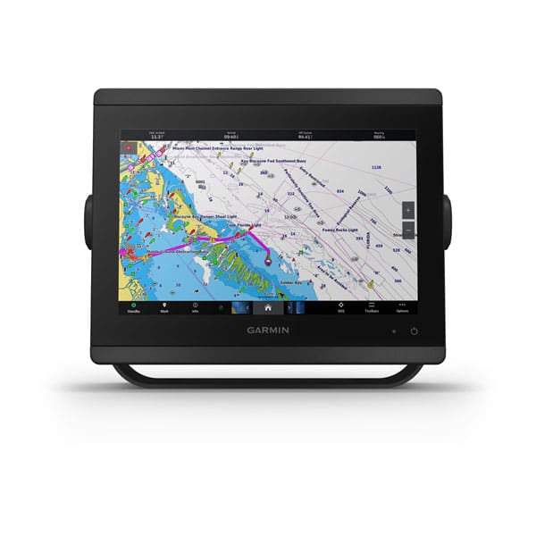
Display: 12-inch full HD IPS touchscreen with anti-glare finish, wide viewing angles, and superb daylight readability; 1920 x 1200 resolution for sharp, easy-to-read charts.
-
Navionics+ Maps & Auto Guidance+: preloaded coastal and inland Navionics+ charts for the U.S. and Canada with Auto Guidance+ planning to assist routing (planning only; not a substitute for safe navigation).
-
Optional Vision+ Content: optional Navionics Vision+ premium map content expands map detail for enhanced guidance.
-
Connectivity & Networking: fully network capable with NMEA 2000 and Garmin Marine Network; ANT connectivity and Wi‑Fi networking to pair with compatible devices like quatix watches and gWind Wireless 2 wind sensor.
-
OneHelm Central Control: central control screen for effortless operation of many third-party devices and systems.
-
Engine, Sonar & Prerace Tools: view RPMs, fuel flow, temperature, trim, and more for up to four Mercury engines via SmartCraft Connect; Panoptix PS51 FrontVü compatibility; SailAssist data and prerace guidance; SmartMode presets for docking, cruising, fishing, and anchoring.
-
App & Charting Ecosystem: built-in Wi‑Fi for ActiveCaptain OneChart access, smart notifications, Garmin Quickdraw Community data, and more; dual microSD slots for expansion and map updates.
-
Navigation Data & Memory: stores up to 5,000 waypoints, 100 routes (250 waypoints per route), and a track log of 50,000 points with 50 saved tracks.
-
Storage & Expansion: accepts two microSD cards on the back to support ActiveCaptain app expansion and cartography accessories for flexible map storage and updates.
-
Mounting & Rugged Design: supports multiple displays and edge-to-edge mounting or flush installation for a clean cockpit; bail, flat, or flush mounting options (flat-mount hardware not included; professional installation recommended); internal or external antenna via NMEA 2000; IPX6/IPX7 rating for rugged marine use.
-
Radar & Sonar Compatibility: Garmin Radar and Sonar compatibility to pair with supported devices for comprehensive coverage.
This GPSMAP 8612 delivers a complete navigation ecosystem: planning assistance with Auto Guidance+, centralized control via OneHelm, expansive Navionics+ mapping, robust network integration, and forward-looking sonar and engine data capabilities. With ActiveCaptain and OneChart, you can plan, chart, and stay connected on the water, while SailAssist and SmartMode presets help you optimize performance whether cruising, docking, fishing, or racing.
| General |
| Physical dimensions |
11.9" x 8.5" x 3" (30.3 cm x 21.6 cm x 7.6 cm) |
| Weight |
6.0 lbs. |
| Water rating |
IPX6 and IPX7 |
| Display type |
touchscreen IPS display (anti-glare finish) |
| Display size |
10.1" x 5.7" (25.7 cm x 14.5 cm) |
| Display resolution |
FHD; 1920 x 1200 pixels |
| Power consumption |
2.4 A |
| Antenna |
Internal or external over NMEA 2000 |
| Mounting options |
Bail, flat or flush (Garmin do not offer any hardware or accessories for a flat-mount installation. Professional tools and knowledge is required.) |
| Receiver |
10 Hz GPS/GLONASS/Galileo |
| Garmin Marine Network™ ports |
2 |
| Maps & Memory |
| Accepts data cards |
2 microSD cards (on back) |
| Waypoints |
5,000 |
| Routes |
100 (250 waypoints each) |
| Track log |
50,000 points; 50 saved tracks |
| pre-loaded maps |
Garmin Navionics+ coastal and inland water charts for the U.S. and Canada |
| Outdoor Recreation Features |
| Tide tables |
Yes |
| Chartplotter Features |
| Garmin Radar compatible |
Yes |
| Garmin Sonar compatible |
Yes |
| Garmin SmartMode compatible (customizable monitor presets) |
Yes |
| Supports AIS (tracks target ships position) |
Yes |
| Supports DSC (displays position data from DSC-capable VHF radio) |
Yes |
| Supports FUSION-Link™ compatible radios |
Yes |
| GSD™ Black Box sonar support |
Yes |
| GCV™ Black Box sonar support |
Yes |
| ActiveCaptain compatible |
Yes |
| Garmin Helm compatible |
Yes |
| GRID™ (Garmin Remote Input Device) compatible |
Yes |
| Wireless remote compatible |
Yes |
| Sonar Features & Specifications |
| Dual-frequency (50/200 kHz) sonar capable |
Yes (with external black box, sold separately) |
| Dual-beam (77/200 kHz) sonar capable |
Yes (with external black box, sold separately) |
| Frequencies supported |
NA |
| Transmit power |
NA |
| CHIRP sonar technology |
Yes_(when_connected_to_another_compatible_sonar_device) |
| ClearVü |
yes (with GCV™ black box, sold separately) |
| SideVü |
yes (with GCV™ black box, sold separately) |
| Maximum depth |
NA |
| Connections |
| NMEA 2000® compatible |
Yes |
| Transducer pin numbers |
na |
| NMEA 0183 input ports |
1 differential |
| NMEA 0183 output ports |
1 differential |
| Video input ports |
1 - BNC composite
1 - HDMI (HDCP compliant) |
| Video output ports |
1 HDMI |
| Wireless connectivity |
Yes |