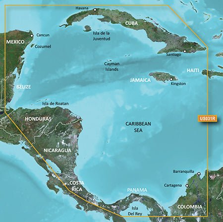
Experience confident navigation with the Garmin HXUS031R G3 Micro SD Southwest Caribbean, a premium chart bundle designed for mariners who demand precise depth data, detailed harbors, and advanced visualization for effective voyage planning.
-
Auto Guidance: Smart routing that analyzes your destination and charts a suggested path, making port-to-port navigation easier and safer.
-
1-Foot Contours (BlueChart g2 HD): Precise bottom structure depiction for improved fishing charts and navigation in swamps, canals, and port plans.
-
Depth Range Shading: View up to 10 depth ranges at a glance, with clear shading to help you target your preferred depths.
-
Shallow Water Shading: Depth shading at a user-defined level to aid navigation in shallow areas.
-
3D Views: MarinerEye and FishEye: Unique perspectives above and below the waterline for enhanced situational awareness.
-
High-Resolution Satellite Imagery: Port, marina, bridge, and landmark imagery for quick recognition and decision-making.
-
Aerial Photography: Includes detailed aerial imagery to support precise chart interpretation.
-
Detailed Coastal Coverage: Northern coast of Central America from Cancun to Barranquilla, including the Panama Canal in its entirety; detailed coverage of Cuba, Jamaica, and the Cayman Islands.
-
Detailed Coastal Roads: Coastal road detail up to 5 miles inland to assist route planning and situational awareness on land and sea.
-
Navigational Aids, Spot Soundings, Depth Contours, Tides & Currents: Comprehensive data to guide your boat in and out of port with confidence.
-
Worldwide Coverage: Global availability with the New Chart Guarantee and a discount update program to keep charts current.
This dataset delivers depth, clarity, and confidence across every leg of Caribbean navigation—from busy ports to offshore passages. With 1-foot HD contours, depth shading, and comprehensive tides, currents, and navigational aids, you can plan and execute routes with precision. The 3D perspectives, high-resolution imagery, and coastal roads inland provide a holistic view of both sea and land, helping you anticipate hazards, recognize landmarks, and optimize fishing and cruising itineraries. Global coverage plus updates ensures your charts stay current for trips spanning Cancun, Barranquilla, the Panama Canal, Cuba, Jamaica, and the Cayman Islands.
| g2 HD |
| 1' HD Contours |
Yes |
| Depth Range Shading |
Yes |
| Shallow Water Shading |
Yes |
| Navigational aids, spot soundings, depth contours, tides and currents and detailed harbors and marinas |
Yes |
| g2 Vision HD |
| 1' HD Contours |
Yes |
| Depth Range Shading |
Yes |
| Shallow Water Shading |
Yes |
| Navigational aids, spot soundings, depth contours, tides and currents and detailed harbors and marinas |
Yes |
| Auto Guidance |
Yes |
| 3-D Views (MarinerEye and FishEye) |
Yes |
| High Resolution Satellite Imagery |
Yes |
| Aerial Photography |
Yes |
| Detailed coastal roads up to 5 miles inland |
Yes |