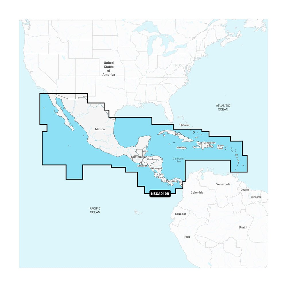
The Garmin Navionics+ NSSA010R Central America & Caribbean is a comprehensive all-in-one map designed for Garmin chartplotters, tailored for boaters navigating the Central America and Caribbean region. It blends coastal and inland data in the familiar Navionics style palette for confident planning and plotting.
-
All‑in‑one mapping for Garmin chartplotters: load and view detailed coastal features, lakes, rivers, and more with a single, integrated map solution.
-
Extensive regional coverage: West coast of Mexico from Tijuana to Panama (including the Panama Canal), East Coast from Panama to Brownsville, TX, and detailed Caribbean coverage across the Far Bahamas, Turks & Caicos, Cuba, Jamaica, the Caymans, Haiti, the Dominican Republic, Puerto Rico, and the Lesser Antilles to Grenada.
-
MicroSD/SD loading format: easy loading of Navionics+ content with worldwide boating coverage embedded in one map.
-
Integrated Garmin and Navionics data: unified data for reliable plotting and planning across regions.
-
Daily chart updates: up to 5,000 updates daily, with a one-year subscription that includes access to daily updates via the ActiveCaptain app.
-
Auto Guidance+ technology: combines Garmin and Navionics routing to provide dock-to-dock path suggestions through channels, inlets, marina entrances, and more (planning use only).
-
Depth shading and high-detail contours: high-resolution depth shading with up to 10 color-shaded target depth ranges and contours up to 1' for precise bottom detail.
-
Shallow water shading: clear visualization of shallow areas to help avoid hazards.
-
NOAA raster cartography: available for some U.S. waters as a free download via the ActiveCaptain app to provide paper-chart-like views on a plotter; cannot be viewed on echoMAP CHIRP and ECHOMAP Plus combos but viewable on mobile devices via ActiveCaptain.
-
ActiveCaptain Community: access community-sourced POIs—marinas, anchorages, hazards, businesses, and more—with recommendations from boaters familiar with local waters.
-
One-year subscription: includes daily updates and access to new content downloads; renew to continue enjoying fresh data and features.
-
Comprehensive inland and offshore content: Navionics+ NSSA010R delivers a true All-In-One Map Solution for Garmin chartplotters worldwide, designed for ease of use and visual clarity.
-
Vibrant colors and user-friendly interface: Navionics+ NSSA010R brings vibrant colors and a user-friendly interface to your navigation and fishing planning, helping you make faster, smarter decisions on the water with up-to-date data and community insights.
With this Navionics+ NSSA010R, you gain a true all-in-one map that blends inland and offshore coverage for Garmin chartplotters. Daily updates—up to 5,000—and a one-year subscription keep charts current, while Auto Guidance+ offers dock-to-dock routing through channels and marina entrances for planning. Depth shading and 1' contours provide precise bottom detail, and shallow-water shading helps you avoid hazards. NOAA raster cartography is available where supported, viewable via ActiveCaptain on mobile devices, and the ActiveCaptain Community adds boaters’ POIs and recommendations. The MicroSD/SD loading format makes deployment simple, and the included one-year subscription ensures ongoing access to fresh data and features.