Couldn't load pickup availability
About the Product
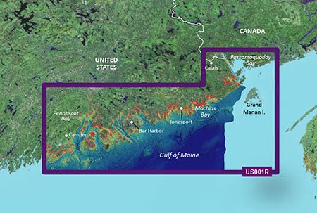
Discover unmatched coastal navigation with the Garmin VUS001R Vision G3 North Maine (Model: 010-C0702-00). This charting powerhouse delivers industry-leading coverage, clarity, and detail for the waters from Calais to Camden, including Bar Harbor and Penobscot Bay.
Powerful Coastal Charting and Data Integration
- BlueChart g3 Vision coastal charts provide industry-leading coverage, clarity, and detail with integrated Garmin and Navionics data.
- Auto Guidance technology uses your desired depth and overhead clearance to calculate a route and a suggested path to follow.
- High-resolution relief shading uses color and shadow to give you a clearer view of bottom structure than contour lines alone.
- Depth range shading offers up to 10 depth ranges so you can spot your target depth at a glance.
- Up to 1' contours provide precise bottom detail for improved fishing charts and navigation in swamps, canals and marinas.
- Shallow water shading helps designate shallow zones you need to avoid.
- NOAA raster cartography is available as a free downloadable feature via the ActiveCaptain app.
- MarinerEye and FishEye views offer perspectives above and below the water line for enhanced situational awareness.
- Detailed images of ports, marinas, bridges and navigational landmarks help you navigate with confidence.
- 3-D views, high-resolution relief imagery, and aerial photos deliver a vivid, paper-chart-like experience on your display.
Experience unparalleled coverage and brilliant detail on the water with the Garmin VUS001R Vision G3 North Maine—the ideal choice for anglers and mariners navigating the rugged Maine coast.
| BlueChart g3 Vision | |
| Integrated Garmin and Navionics content | Yes |
| Auto Guidance technology | Yes |
| Depth range shading | Yes |
| Up to 1' contours | Yes |
| Shallow water shading | Yes |
| Raster cartography | Yes |
| High-resolution relief shading | Yes |
| Unique 3-D views | Yes |
| High-resolution relief imagery | Yes |
| Aerial photos | Yes |
| BlueChart g3 | |
| Integrated Garmin and Navionics content | No |
| Auto Guidance technology | No |
| Depth range shading | No |
| Up to 1' contours | No |
| Shallow water shading | No |
| Raster cartography | No |
Text block