The Garmin VUS003R Vision G3 Cape Cod is a premium coastal navigation card designed for serious boaters and anglers who demand reliable coverage, crystal-clear detail, and advanced charting along the Atlantic coast near Cape Cod.
-
BlueChart g3 Vision integrated charting: Integrated Garmin and Navionics content for comprehensive coverage and rich detail.
-
Auto Guidance technology: Uses your desired depth and overhead clearance to calculate routes and suggest a safe, efficient path to follow.
-
Depth range shading: Supports up to 10 depth ranges to view target depths at a glance and shade shallow waters to help avoid hazards.
-
Up to 1' contour detail: Delivers precise bottom depiction for improved fishing charts and navigation in swamps, canals, and marinas.
-
Shallow water shading: Emphasizes shallow areas to help you steer clear of hazards near shore.
-
Raster cartography: NOAA raster cartography option available as a free download via the ActiveCaptain app.
-
High-resolution relief shading: Color and shadow highlight bottom structure for an easier, clearer view than contour lines alone.
-
Unique 3-D views: MarinerEye and FishEye views provide context above and below the waterline for better situational awareness.
-
Aerial photos: Detailed port and landmark imagery for superior navigational context.
-
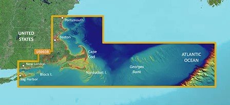
Coverage area: Gloucester, MA through New London, CT, including Narragansett Bay, Block Island, Martha's Vineyard, Nantucket Island, and Cape Cod, with general coverage of Georges Bank.
With integrated BlueChart g3 Vision, Auto Guidance, depth-aware shading, and up-to-date coastal imagery, this chart card delivers clearer seabed detail and smarter routing along Cape Cod and beyond. The combination of high-resolution relief shading, 3-D views, and aerial photos enhances situational awareness when charting trips, navigating marinas, or planning coastal routes across the region.
| BlueChart g3 Vision |
| Integrated Garmin and Navionics content |
Yes |
| Auto Guidance technology |
Yes |
| Depth range shading |
Yes |
| Up to 1' contours |
Yes |
| Shallow water shading |
Yes |
| Raster cartography |
Yes |
| High-resolution relief shading |
Yes |
| Unique 3-D views |
Yes |
| High-resolution relief imagery |
Yes |
| Aerial photos |
Yes |
| BlueChart g3 |
| Integrated Garmin and Navionics content |
No |
| Auto Guidance technology |
No |
| Depth range shading |
No |
| Up to 1' contours |
No |
| Shallow water shading |
No |
| Raster cartography |
No |