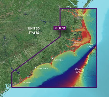
Navigate the coast from Norfolk to Charleston with confidence using the Garmin VUS007R Vision G3 Norfolk–Charleston chart card. Built around BlueChart g3 Vision coastal charts, it merges Garmin and Navionics data to deliver detailed coastal navigation, enhanced fishing charts, and smarter routing.
-
BlueChart g3 Vision integrated data: Combines Garmin and Navionics content to deliver richer coastlines, clearer fishing charts, and deeper mariner insight.
-
Auto Guidance technology: Calculates routes based on your preferred depth and overhead clearance, and suggests safe passages through busy ports, swamps, canals, and marinas.
-
Depth range shading: Displays up to 10 depth ranges to view target depths at a glance.
-
Up to 1' contours: High-precision 1-foot contours for detailed bottom features in swamps, canals, and marinas.
-
Shallow water shading: Clear designation of shallow areas to help you avoid hazards.
-
Raster cartography: NOAA raster cartography available as a free downloadable feature via the ActiveCaptain app for a paper-chart look.
-
High-resolution relief shading: Blends color and shadow to reveal bottom structure more clearly than contour lines alone.
-
Unique 3-D views: Dynamic perspectives that enhance situational awareness above and below the water line.
-
High-resolution relief imagery: Detailed imagery to improve interpretation of seabed features.
-
Aerial photos: Contextual imagery accompanying the charts for broader situational understanding.
-
Coverage: Newport News, VA to Charleston, SC, including Pamlico Sound, Cape Lookout, and Cape Romain.
Designed for serious coastal users, this chart card delivers precise, easy-to-interpret coastal information that supports safer, smarter voyages. The integrated BlueChart g3 Vision data and Auto Guidance improve routing and decision-making, while high‑resolution relief shading and 3-D views help visualize bottom features and hazards at a glance. NOAA raster cartography via ActiveCaptain offers a convenient paper-chart reference when needed, and the broad coverage from Newport News to Charleston keeps you oriented along the coast.
| BlueChart g3 Vision |
| Integrated Garmin and Navionics content |
Yes |
| Auto Guidance technology |
Yes |
| Depth range shading |
Yes |
| Up to 1' contours |
Yes |
| Shallow water shading |
Yes |
| Raster cartography |
Yes |
| High-resolution relief shading |
Yes |
| Unique 3-D views |
Yes |
| High-resolution relief imagery |
Yes |
| Aerial photos |
Yes |
| BlueChart g3 |
| Integrated Garmin and Navionics content |
No |
| Auto Guidance technology |
No |
| Depth range shading |
No |
| Up to 1' contours |
No |
| Shallow water shading |
No |
| Raster cartography |
No |