Navigate every mile of the Charleston to Jacksonville coast with the Garmin VUS008R Vision G3 chart bundle. Built on BlueChart g3 Vision coastal charts, this bundle delivers industry-leading coverage, crystal-clear detail, and integrated Garmin and Navionics data for confident coastal boating, fishing, and cruising.
Key features at a glance
-
Auto Guidance technology: Uses your desired depth and overhead clearance to calculate a route and show a suggested path to follow, helping you steer around shallow areas and obstacles.
-
High-resolution relief shading: Color and shadow illuminate bottom structure for an intuitive, easy-to-interpret view beyond contour lines.
-
Depth range shading and up to 10 depth ranges: View target depths at a glance with precise shading to spot channels, reefs, and drop-offs.
-
Up to 1' contours: Extremely detailed bottom depiction for improved fishing charts and navigation in swamps, canals and marinas.
-
Shallow water shading: Clearly designate shallow zones to avoid hazards and protect sensitive areas.
-
Raster cartography via NOAA: NOAA raster charts available as a free download through the ActiveCaptain app for a paper-chart feel on screen.
-
MarinerEye and FishEye views: Enhanced perspectives above and below the water line for superior situational awareness and fishing planning.
-
Aerial photos and 3-D views: Realistic imagery of ports, marinas, bridges and navigational landmarks for precise orientation.
-
Integrated Garmin and Navionics data: Combines the best of both data sets for comprehensive, reliable coastal charts.
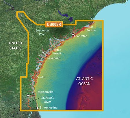
Coast-to-coast coverage
The Vision chart coverage spans from Cape Romain through St. Augustine, including Charleston, Savannah and Jacksonville, with the St. John’s River covered to the Clay County line. This breadth ensures you have detailed charts for busy waterways, shallow channels, and marina corridors along the Atlantic coast.
The Garmin VUS008R G3 Vision Charleston to Jacksonville delivers precise charts, smart shading, and powerful navigation tools designed to boost confidence on the water—whether you’re fishing, cruising, or docking in busy ports.
| BlueChart g3 Vision |
| Integrated Garmin and Navionics content |
Yes |
| Auto Guidance technology |
Yes |
| Depth range shading |
Yes |
| Up to 1' contours |
Yes |
| Shallow water shading |
Yes |
| Raster cartography |
Yes |
| High-resolution relief shading |
Yes |
| Unique 3-D views |
Yes |
| High-resolution relief imagery |
Yes |
| Aerial photos |
Yes |
| BlueChart g3 |
| Integrated Garmin and Navionics content |
No |
| Auto Guidance technology |
No |
| Depth range shading |
No |
| Up to 1' contours |
No |
| Shallow water shading |
No |
| Raster cartography |
No |