Garmin VUS010R Vision Southeast Florida is a marine navigation system designed for coastal cruisers and serious anglers, delivering coast-focused charts and precise depth data for Florida and the Bahamas with integrated Garmin and Navionics content for comprehensive coverage.
-
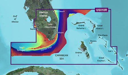
Coverage area: Florida region from Vero Beach south to Lake Okeechobee, the Florida Keys, Dry Tortugas, and the west coast up to Naples, plus extensive Bahamas coverage across Andros, Eleuthera, Cat Island, Great Exuma, Little Exuma and Hog Cay.
-
BlueChart g3 Vision integration: Integrated Garmin and Navionics data for industry-leading coverage, clarity and detail.
-
Auto Guidance technology: Uses your desired depth and overhead clearance to calculate a route and present a suggested path to follow.
-
Depth range shading: Visual depth shading with support for multiple depth ranges to help interpret seabed structure.
-
Up to 1' contours: High-resolution contour detail for accurate depiction of bottom structure in swamps, canals and marinas.
-
Shallow water shading: Highlights shallow areas to improve safety in tricky waters.
-
Raster cartography: Includes raster chart layers for reference and familiar chart textures.
-
High-resolution relief shading: Blends color and shadow to reveal bottom structure more clearly than contour lines alone.
-
Unique 3-D views: Provides additional perspectives to better interpret terrain and shoreline features.
-
High-resolution relief imagery: Rich imagery to visualize coastal environments and landmarks.
-
Aerial photos: Includes aerial imagery to enhance situational awareness of coastal areas.
-
MarinerEye and FishEye views: Offers above- and below-water perspectives for planning and decision-making.
-
NOAA raster cartography via ActiveCaptain: Free download option to access NOAA raster charts with an authentic paper-chart feel on your display.
With these features, you gain precise depth data and intuitive routing; the integrated BlueChart g3 Vision data ensures comprehensive coverage for both Garmin and Navionics content, supporting safer navigation. The 3-D views, high-resolution imagery and aerial photos provide rich context for planning coastal itineraries, fishing spots, and entry corridors. In short, you’ll experience clearer charts, smarter routing, and enhanced situational awareness for Florida’s coast and the Bahamas.
| BlueChart g3 Vision |
| Integrated Garmin and Navionics content |
Yes |
| Auto Guidance technology |
Yes |
| Depth range shading |
Yes |
| Up to 1' contours |
Yes |
| Shallow water shading |
Yes |
| Raster cartography |
Yes |
| High-resolution relief shading |
Yes |
| Unique 3-D views |
Yes |
| High-resolution relief imagery |
Yes |
| Aerial photos |
Yes |
| BlueChart g3 |
| Integrated Garmin and Navionics content |
No |
| Auto Guidance technology |
No |
| Depth range shading |
No |
| Up to 1' contours |
No |
| Shallow water shading |
No |
| Raster cartography |
No |