Meet the Garmin VUS013R Vision G3 Mobile — the coastal navigation companion built for Lake Charles and nearby waters. By combining Garmin and Navionics data, it delivers ultra-detailed charts, realistic bottom visualization, and trusted guidance for coastal trips and fishing.
-
Integrated Garmin and Navionics content: Delivers comprehensive coastal coverage and rich detail for navigation and fishing.
-
Auto Guidance technology: Uses your desired depth and overhead clearance to calculate a safe route and present a recommended path to follow.
-
Depth range shading: Supports up to 10 depth ranges, letting you spot target depths at a glance for precise fishing and navigation.
-
Up to 1' contours: Up to 1' contour intervals deliver an ultra-detailed depiction of bottom features, enhancing fishing charts and navigation in swamps, canals, and marinas.
-
Shallow water shading: Shallow water shading helps you avoid shallow zones, improving safety and planning in near-shore waters.
-
Raster cartography: Raster cartography provides detailed imagery to support precise navigation.
-
High-resolution relief shading: High-resolution relief shading provides depth with color and shadow, offering a clearer view of bottom structure than contour lines alone.
-
Unique 3-D views: Unique 3-D views enhance situational awareness with immersive visualization.
-
High-resolution relief imagery: High-resolution relief imagery adds realistic depth cues to the charts for easier interpretation.
-
Aerial photos: Aerial photos provide additional context for coastal navigation.
-
NOAA raster cartography via ActiveCaptain: Offers a traditional visuals option as a free download for those who prefer paper-chart visuals.
-
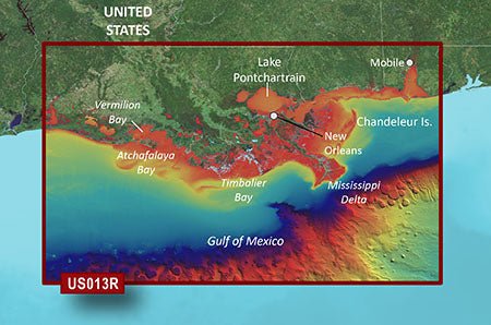
Extensive regional coverage: Spans Mobile, AL through Calcasieu Lake, LA, including New Orleans, the Mississippi River Delta, Lake Pontchartrain, Lake Maurepas, and Vermilion Bay for confident coastal planning.
-
MarinerEye and FishEye views: Adds above- and below-water perspectives to boost situational awareness.
With Vision G3 Mobile, you gain a trusted charting solution that combines depth-aware navigation, realistic bottom portrayal, and broad coastal coverage. Auto Guidance helps you plan safe routes around shallow waters and overhead obstacles, while high-detail contours and shading reveal bottom structures for better fishing and anchoring decisions. NOAA raster cartography via ActiveCaptain provides a traditional visuals option as a free download, and MarinerEye and FishEye views add context to boost situational awareness. Whether plotting a safe passage through swamps, navigating marinas, or targeting prime fishing spots along the coast, the VUS013R Vision G3 Mobile delivers clear, reliable data you can count on.
| BlueChart g3 Vision |
| Integrated Garmin and Navionics content |
Yes |
| Auto Guidance technology |
Yes |
| Depth range shading |
Yes |
| Up to 1' contours |
Yes |
| Shallow water shading |
Yes |
| Raster cartography |
Yes |
| High-resolution relief shading |
Yes |
| Unique 3-D views |
Yes |
| High-resolution relief imagery |
Yes |
| Aerial photos |
Yes |
| BlueChart g3 |
| Integrated Garmin and Navionics content |
No |
| Auto Guidance technology |
No |
| Depth range shading |
No |
| Up to 1' contours |
No |
| Shallow water shading |
No |
| Raster cartography |
No |