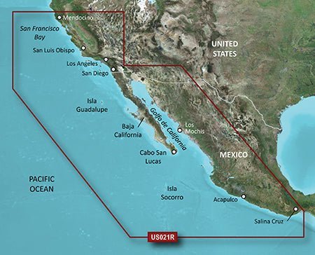
The Garmin VUS021R Vision G3 California-Mexico is a premium chartplotter built for serious mariners and anglers, delivering official-chart accuracy and immersive navigation tools for confident coastal adventures.
-
1' HD Contours: Ultra-precise depth contours at 1-foot intervals for incredibly detailed seafloor depictions.
-
Depth Range Shading: View up to 10 depth ranges at a glance to pinpoint the exact depths you need.
-
Shallow Water Shading: Clear visual cues to help you stay within your preferred depth limits.
-
Navigational aids, spot soundings, depth contours, tides and currents and detailed harbors and marinas: Comprehensive data for safer passages, moorings, and port planning.
-
Auto Guidance: Automatically calculates a practical route tailored to your boat’s dimensions and capabilities.
-
3-D Views (MarinerEye and FishEye): Immersive perspectives above and below the waterline for enhanced situational awareness.
-
High-Resolution Satellite Imagery: Realistic overlays that help you recognize ports, marinas, bridges, and landmarks as you navigate.
-
Aerial Photography: Crystal-clear detail in unfamiliar ports and harbors to assist mooring and approaches.
-
Detailed coastal roads up to 5 miles inland: Inland road data aids safer coastal navigation and planning.
-
California–Mexico Comprehensive Coverage: Includes Point Arena to Puerto Vallarta, Mendocino, San Francisco Bay, Channel Islands, San Diego, the Baja Peninsula, and coastal areas such as Cabo San Lucas, Mazatlan, Acapulco, and Salina Cruz.
-
Worldwide Coverage & Updates: Dependable charts wherever you voyage, with Garmin’s New Chart Guarantee and a discount card update program.
Designed to keep you informed, prepared, and confident on every voyage, the VUS021R Vision G3 supports precise coastal navigation and smarter planning. Use 1' HD Contours to read the seafloor at a glance, rely on Depth Range and Shallow Water shading to avoid shallow spots, and let Auto Guidance plot practical routes tailored to your boat. 3-D views provide situational awareness above and below the water, while High-Resolution Satellite Imagery and Aerial Photography help you recognize ports, marinas, bridges, and landmarks before you arrive. Inland coastal roads expand planning options up to 5 miles inland, and Worldwide Coverage with updates and the New Chart Guarantee keeps charts current wherever you travel. California–Mexico coverage spans major coastal regions and popular destinations—from Mendocino and San Francisco Bay to Cabo San Lucas and Puerto Vallarta—so you can fish, cruise, or navigate busy ports with confidence.
| g2 HD |
| 1' HD Contours |
Yes |
| Depth Range Shading |
Yes |
| Shallow Water Shading |
Yes |
| Navigational aids, spot soundings, depth contours, tides and currents and detailed harbors and marinas |
Yes |
| g2 Vision HD |
| 1' HD Contours |
Yes |
| Depth Range Shading |
Yes |
| Shallow Water Shading |
Yes |
| Navigational aids, spot soundings, depth contours, tides and currents and detailed harbors and marinas |
Yes |
| Auto Guidance |
Yes |
| 3-D Views (MarinerEye and FishEye) |
Yes |
| High Resolution Satellite Imagery |
Yes |
| Aerial Photography |
Yes |
| Detailed coastal roads up to 5 miles inland |
Yes |