Explore the crystal-clear waters of the Southern Bahamas with the Garmin VUS029R Vision G3. This advanced coastal chartplotter delivers industry-leading coverage and unmatched clarity for navigation, fishing, and exploration on the water.
Key capabilities
-
BlueChart g3 Vision coastal charts with integrated Garmin and Navionics data for comprehensive mapping and detail.
-
Auto Guidance uses your desired depth and overhead clearance to calculate a route and a suggested path to follow.
-
High-resolution relief shading combines color and shadow to give you a clearer view of bottom structure than contour lines alone.
-
Depth Range Shading provides up to 10 depth ranges, enabling you to view your target depth at a glance.
-
Up to 1' contours for a more accurate depiction of bottom structure, improving fishing charts and navigation in swamps, canals and marinas.
-
Shallow water shading helps designate shallow depths to avoid, enhancing safety in challenging waters.
-
Raster cartography offers NOAA-style maps as a free downloadable feature via the ActiveCaptain app, providing a familiar paper-chart look on a modern display.
-
MarinerEye and FishEye views deliver additional perspective both above and below the water line for improved situational awareness.
-
High-resolution relief imagery and Aerial photos enrich visualization, making it easier to identify shoreline features and underwater structures.
-
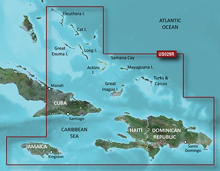
Detailed regional coverage spans Eleuthera Island, Bahamas to the Dominican Republic, including Great Exuma, Great Inagua, Mayaguana, and many other Bahamian islands, with comprehensive coverage of the Jamaican, Haitian, and Dominican coasts, the easternmost quarter of Cuba, and the Turks and Caicos Islands.
Experience unparalleled coverage and brilliant detail on the water with the Garmin VUS029R Vision G3 Southern Bahamas—a powerful tool for confident navigation, precise fishing charts, and immersive coastal exploration.
| BlueChart g3 Vision |
| Integrated Garmin and Navionics content |
Yes |
| Auto Guidance technology |
Yes |
| Depth range shading |
Yes |
| Up to 1' contours |
Yes |
| Shallow water shading |
Yes |
| Raster cartography |
Yes |
| High-resolution relief shading |
Yes |
| Unique 3-D views |
Yes |
| High-resolution relief imagery |
Yes |
| Aerial photos |
Yes |
| BlueChart g3 |
| Integrated Garmin and Navionics content |
Yes |
| Auto Guidance technology |
Yes |
| Depth range shading |
Yes |
| Up to 1' contours |
Yes |
| Shallow water shading |
Yes |
| Raster cartography |
Yes |