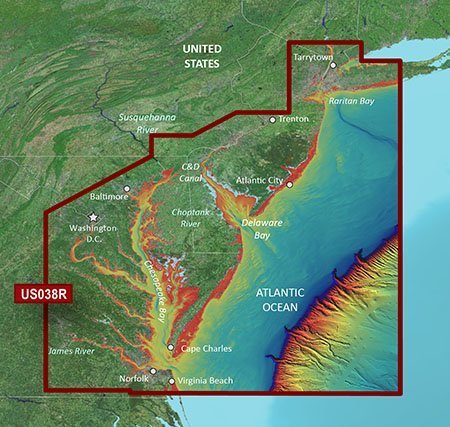
Precision coastal navigation data on a microSD/SD card for Garmin chartplotters, designed for serious navigators and anglers. Covering the eastern seaboard from Raritan Bay to Virginia Beach, it blends Garmin and Navionics data in BlueChart g3 Vision for unrivaled clarity and detail.
-
Coverage Area: Extensive eastern seaboard coverage from Raritan Bay to Virginia Beach, including the New Jersey coastline, the C&D Canal, Delaware Bay, the Delaware River to Trenton, Chesapeake Bay, Baltimore, the Potomac River to Washington D.C., Chincoteague Bay, Cape Charles, Newport News, and Norfolk.
-
Chart Data: BlueChart g3 Vision coastal charts with integrated Garmin and Navionics data for clarity and detail.
-
Auto Guidance: Uses your desired depth and overhead clearance to calculate a route and present a recommended path to follow.
-
High-Resolution Relief Shading: Color and shadow shading to provide a clearer, easier-to-interpret view of bottom structure beyond contour lines.
-
Depth Range Shading: Supports up to 10 depth ranges with up to 1’ contours to help identify target depths quickly, including in swamps, canals, and marinas.
-
MarinerEye and FishEye Views: Offer perspectives above and below the water line for better situational awareness.
-
NOAA Raster Cartography via ActiveCaptain: Available as a free downloadable feature for a paper-chart-like display option.
-
Card Format and Compatibility: microSD/SD card (010-C1004-00) designed for easy updates and compatibility with Garmin devices.
-
Designed for Navigators and Anglers: Delivers precise bottom detail and trustworthy routing to navigate busy waterways, plan efficient passages, and locate productive fishing grounds with confidence.
With the VUS038R G3 Vision New York to Chesapeake, you gain precise bottom detail and reliable routing to navigate busy waterways, plan efficient passages, and locate productive fishing grounds with confidence. The integrated Garmin and Navionics data across an extensive eastern footprint supports informed decisions in bays, channels, and marinas, while MarinerEye and FishEye views expand awareness above and below the water. Auto Guidance helps you chart practical routes based on depth and overhead clearance, and the high-detail relief shading plus 1' contour precision enhances bottom feature recognition in challenging environments. Optional NOAA raster cartography via ActiveCaptain provides a familiar paper-chart-like display as a quick reference on the water.