Meet the Garmin VUS511L Vision G3 Boston–Norfolk (Model: 010-C0740-00), a premium coastal chart solution built for serious boaters who demand industry-leading coverage, clarity and detail on the water. This chart card blends advanced navigation data with intuitive tools to elevate every voyage along the coast and offshore.
-
BlueChart g3 Vision coastal charts: industry-leading coverage, clarity and detail with integrated Garmin and Navionics data for confident navigation and precise fishing charts.
-
Auto Guidance: uses your desired depth and overhead clearance to calculate a route and show a suggested path to follow, helping you plan smarter passages.
-
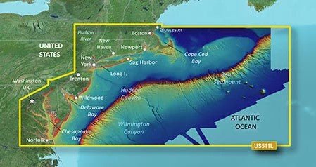
High-resolution relief shading: color and shadow highlight bottom structure for an easier interpretation than contour lines alone.
-
Depth Range Shading: provides up to 10 depth ranges so you can view your target depth at a glance.
-
1’ contour lines: closer, more accurate depiction of bottom structure for improved navigation in swamps, canals and marinas and enhanced fishing charts.
-
NOAA raster cartography: when downloaded via the ActiveCaptain app, you can view paper-chart-like detail for added context and compatibility with NOAA data.
-
MarinerEye and FishEye views: additional perspectives above and below the water line for better situational awareness.
-
Extensive coverage: detailed maps from Gloucester, MA to Wildwood, NJ, including Cape Cod, Martha's Vineyard and Nantucket Island; Long Island Sound, New York Harbor, the Hudson River to its junction with the Mohawk River, and Raritan Bay; offshore bathymetry from Georges Basin to Baltimore Canyon, including Georges Bank and the Bear Seamount, plus the Hudson and Wilmington Canyons.
-
Enhanced coastal navigation: the combination of integrated data, relief shading and precise contouring provides a clearer view of bottom structure for safer, more informed cruising, fishing and marinas navigation.
Designed for anglers, cruisers and coastal navigators, the VUS511L Vision G3 Boston–Norfolk delivers unparalleled detail, powerful routing, and immersive bathymetric insight that helps you navigate with confidence—from busy harbors to secluded waterways.
| BlueChart g3 Vision |
| Integrated Garmin and Navionics content |
Yes |
| Auto Guidance technology |
Yes |
| Depth range shading |
Yes |
| Up to 1' contours |
Yes |
| Shallow water shading |
Yes |
| Raster cartography |
Yes |
| High-resolution relief shading |
Yes |
| Unique 3-D views |
Yes |
| High-resolution relief imagery |
Yes |
| Aerial photos |
Yes |
| BlueChart g3 |
| Integrated Garmin and Navionics content |
Yes |
| Auto Guidance technology |
Yes |
| Depth range shading |
Yes |
| Up to 1' contours |
Yes |
| Shallow water shading |
Yes |
| Raster cartography |
Yes |