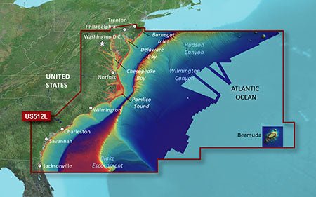
Garmin VUS512L Vision G3 Mid-Atlantic is a premium coastal navigation card designed for serious mariners seeking exceptional clarity, detail, and confidence on the water. It blends BlueChart g3 Vision data with integrated Garmin and Navionics content to deliver extensive coverage across the Mid-Atlantic region and beyond.
-
BlueChart g3 Vision integration: Coastal charts with integrated Garmin and Navionics content for comprehensive coverage, clarity, and detail.
-
BlueChart g3 integration: Integrated Garmin and Navionics content with advanced routing capabilities.
-
Auto Guidance technology: Uses your desired depth and overhead clearance to calculate routes and show a suggested path to follow.
-
Depth range shading: Visualizes up to 10 depth ranges for quick depth reference.
-
Up to 1' contour intervals: Provides precise bottom structure depiction in swamps, canals, and marinas.
-
Shallow water shading: Helps identify and avoid shallow areas at a glance.
-
NOAA raster cartography: Raster cartography available as a free download via the ActiveCaptain app, offering a paper-chart look on screen.
-
High-resolution relief shading: Adds depth perception and terrain awareness to your charts.
-
Unique 3-D views: 3-D perspectives to aid interpretation of coastal contours and features.
-
High-resolution relief imagery: Impressive imagery that enhances chart comprehension and navigation decisions.
-
Aerial photos: High-detail aerial imagery to aid reference and situational awareness.
-
MarinerEye and FishEye views: Perspectives above and below the water line for enhanced situational awareness.
-
Extensive regional coverage: East Coast from Barnegat Inlet, NJ through Jacksonville, FL to Bermuda; full coverage of the Chesapeake Bay, Albemarle and Pamlico Sounds, Cape Fear, the Savannah River to Augusta, and the St. Johns River to Hastings, FL; plus bathymetric data from Hudson Canyon to Blake Escarpment and major canyons.
-
Bathymetric data coverage: Detailed bathymetric data supporting depth-aware navigation across major canyons and offshore features.
-
Designed for serious anglers, cruisers, and offshore navigators: A marine-grade, feature-rich cartography designed to elevate voyages with safer planning and precise navigation.
With this chart card, you gain access to depth-aware routing, rich imagery, and expansive regional data that support safer planning, precise navigation, and enhanced situational awareness across the Mid-Atlantic and surrounding waters.
| BlueChart g3 Vision |
| Integrated Garmin and Navionics content |
Yes |
| Auto Guidance technology |
Yes |
| Depth range shading |
Yes |
| Up to 1' contours |
Yes |
| Shallow water shading |
Yes |
| Raster cartography |
Yes |
| High-resolution relief shading |
Yes |
| Unique 3-D views |
Yes |
| High-resolution relief imagery |
Yes |
| Aerial photos |
Yes |
| BlueChart g3 |
| Integrated Garmin and Navionics content |
Yes |
| Auto Guidance technology |
Yes |
| Depth range shading |
Yes |
| Up to 1' contours |
Yes |
| Shallow water shading |
Yes |
| Raster cartography |
Yes |